When using subsets from the ORNL DAAC's Terrestrial Ecology Subsetting & Visualization Services (TESViS), please cite both the specific tool(s) used and the specific data product(s). The citation is also sent in the email (as plain text and BibTeX file attachment) along with the data retrieval instructions after the order is processed.
Tool Citation
Format (single site):
ORNL DAAC 2018. Terrestrial Ecology Subsetting & Visualization Services (TESViS) Global Subsets Tool. ORNL DAAC, Oak Ridge, Tennessee, USA. Accessed Month dd, yyyy. Subset obtained for [Product name] product at [Lat],[Lon], time period: [Start date] to [End date], and subset size: [Width] x [Height] km. https://doi.org/10.3334/ORNLDAAC/1379
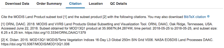
Example (single site): ORNL DAAC. 2018. Terrestrial Ecology Subsetting & Visualization Services (TESViS) Global Subsets Tool. ORNL DAAC, Oak Ridge, Tennessee, USA. Accessed March 28, 2018. Subset obtained for MOD13Q1 product at 35.9587N,84.2874W, time period: 2000-02-18 to 2018-02-18, and subset size: 100.25 x 100.25 km. https://doi.org/10.3334/ORNLDAAC/1379
Notes:
- The coordinates used in the citation are the Latitude and Longitude (decimal degrees) specified by the user when the order is placed, trimmed to 4 decimal places.
- The citation is also sent in the email along with data retrieval instructions after the order is processed.
- BibTeX (.bib) file is available for download on the data visualization and download page (see screenshot below).
Format (multiple sites, clustered together):
ORNL DAAC 2018. Terrestrial Ecology Subsetting & Visualization Services (TESViS) Global Subsets Tool. ORNL DAAC, Oak Ridge, Tennessee, USA. Accessed Month dd, yyyy. Subset obtained for [Product name] product at various sites in Spatial Range: N=DD.DD, S=DD.DD, E=DDD.DD, W=DDD.DD, time period: [Start date] to [End date], and subset size: [Width] x [Height] km. https://doi.org/10.3334/ORNLDAAC/1379
Example (multiple sites, clustered together):
ORNL DAAC. 2018. Terrestrial Ecology Subsetting & Visualization Services (TESViS) Global Subsets Tool. ORNL DAAC, Oak Ridge, Tennessee, USA. Accessed March 28, 2018. Subset obtained for MOD13Q1 product at various sites in Spatial Range: N=39.49N, S=39.25N, E=107.42W, W=106.48W, time period: 2000-02-18 to 2018-02-18, and subset size: 0.25 x 0.25 km. https://doi.org/10.3334/ORNLDAAC/1379
Notes:
- "Spatial Range: N=DD.DD, S=DD.DD, E=DDD.DD, W=DDD.DD" is the bounding box for the site locations used for requesting subsets.
- Please cite each product separately.
- The coordinates used in the citation are the Latitude and Longitude (decimal degrees) specified by the user when the order is placed, trimmed to 4 decimal places.
- The citation is also sent in the email along with data retrieval instructions after the order is processed.
- BibTeX (.bib) file is available for download on the data visualization and download page. Please modify it manually for multiple sites.
Data Products Citation
Individual citations are available for MODIS products.
Individual citations are available for VIIRS products.
Individual citations are available for SMAP products.
Individual citations are available for ECOSTRESS products.
Individual citations are available for GEDI products.
Individual citations are available for SIF products.
Individual citations are available for ATLAS/ICESat-2 products.